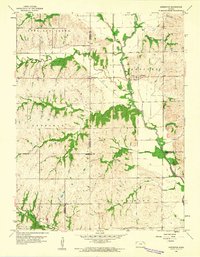
1960 Map of Arrington
USGS Topo · Published 1961About this map
Arrington and Larkinburg serve as the primary hubs in this corner of Northeast Kansas, where the boundaries of Jackson, Atchison, and Jefferson counties converge. The terrain is defined by the winding course of the Delaware River, which draws in a network of tributaries including Straight Creek, Elk Creek, and Catamount Creek. This landscape reflects a mid-century rural economy, with a small Landing Field situated just west of Larkinburg and a Gravel Pit located near the eastern edge of the quadrangle. Local history is anchored by several rural settlements and burial grounds such as Larkinburg Cem and Miller Cem. Farther south, the community of Nebo sits along Nebo Creek, while the settlement of South Denison marks the southwestern reaches of the study area, illustrating the dispersed residential patterns typical of the era before significant urbanization changed the local road and rail infrastructure.
Find a feature on this map
22 named features on this map. Tap any name to fly to it.
Don’t see what you’re looking for? This feature index may not catch every label — zoom into the map to look around manually.
Map Details
Editions of this 1960 Arrington Map
3 editions found
Other maps of this area

1885 · Atchison
USGS Topo · 1:125,000

1886 · Oskaloosa
USGS Topo · 1:125,000

1888 · Oskaloosa
USGS Topo · 1:125,000

1888 · Atchison
USGS Topo · 1:125,000

1888 · Hiawatha
USGS Topo · 1:125,000

1889 · Topeka
USGS Topo · 1:125,000

1893 · Atchison
USGS Topo · 1:125,000

1894 · Oskaloosa
USGS Topo · 1:125,000

1894 · Topeka
USGS Topo · 1:125,000

1894 · Hiawatha
USGS Topo · 1:125,000