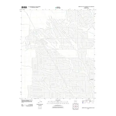
2010 Map of Arroyo de las Calabacillas
USGS Topo · Published 2010About this map
Rio Rancho serves as the focal point of this 2010 topographic study, showcasing the suburban expansion and planned grid system that defines this portion of Sandoval County. The landscape is deeply carved by numerous ephemeral drainage systems, most notably the winding Arroyo de las Calabacillas and the Arroyo de los Montoyas, which dictate the alignment of the local road network. The map reveals an intricate web of residential development, with numbered avenues and major thoroughfares like Progress Blvd and King Blvd NE cutting through the desert terrain. This specific era shows the transitional state of the region's growth, where high-density street plats meet the natural topography of Arroyo Alano and One Arroyo. The detailed street-level data offers a clear look at the infrastructure that supported the rapid population increase in the Albuquerque metropolitan area during the early 21st century.
Find a feature on this map
82 named features on this map. Tap any name to fly to it.
Don’t see what you’re looking for? This feature index may not catch every label — zoom into the map to look around manually.
Map Details
Editions of this 2010 Arroyo de las Calabacillas Map
This is the sole edition of this map. No revisions or reprints were ever made.
Other maps of this area

1888 · Bernalillo
USGS Topo · 1:125,000

1889 · Albuquerque
USGS Topo · 1:125,000

1893 · Albuquerque
USGS Topo · 1:125,000

1934 · Griegos
USGS Topo · 1:24,000

1938 · Albuquerque
USGS Topo · 1:62,500

1953 · Bernalillo NW
USGS Topo · 1:24,000

1954 · Volcano Ranch
USGS Topo · 1:24,000

1954 · Loma Machete
USGS Topo · 1:24,000

1954 · Sky Village
USGS Topo · 1:24,000
1954 · Sky Village SE
USGS Topo · 1:24,000