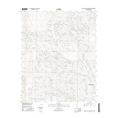
2017 Map of Arroyo de las Calabacillas
USGS Topo · Published 2017About this map
Rio Rancho's modern suburban grid expands across this high desert landscape, characterized by a complex network of residential streets and deep natural drainages. The most prominent hydrological feature, Arroyo de las Calabacillas, carves a winding path from the northwest toward the southeast, serving as the primary relief for the area's storm runoff. This 2017 survey reflects the significant late-20th and early-21st-century residential development in Sandoval County, where street names like Shenandoah Rd NW, Rainbow Blvd NW, and Yosemite Rd NW indicate the planned growth of the city. While the southern and eastern portions of the map show dense development, the western margins transition into open terrain marked by Navajo Draw, Otis Arroyo, and Arroyo Alamo, illustrating the intersection of modern municipal expansion with the ancient desert topography of New Mexico.
Find a feature on this map
320 named features on this map. Tap any name to fly to it.
Don’t see what you’re looking for? This feature index may not catch every label — zoom into the map to look around manually.
Map Details
Editions of this 2017 Arroyo de las Calabacillas Map
This is the sole edition of this map. No revisions or reprints were ever made.
Other maps of this area

1888 · Bernalillo
USGS Topo · 1:125,000

1889 · Albuquerque
USGS Topo · 1:125,000

1893 · Albuquerque
USGS Topo · 1:125,000

1934 · Griegos
USGS Topo · 1:24,000

1938 · Albuquerque
USGS Topo · 1:62,500

1953 · Bernalillo NW
USGS Topo · 1:24,000

1954 · Volcano Ranch
USGS Topo · 1:24,000

1954 · Loma Machete
USGS Topo · 1:24,000

1954 · Sky Village
USGS Topo · 1:24,000
1954 · Sky Village SE
USGS Topo · 1:24,000