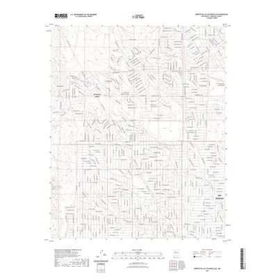
2023 Map of Arroyo de las Calabacillas
USGS Topo · Published 2023About this map
Rio Rancho Estates and the expanding footprint of Rio Rancho define this high-desert landscape in Sandoval County. The terrain is intricately carved by an extensive drainage system, most notably the Arroyo de las Calabacillas which serpentines across the central portion of the map. Other significant watercourses including Arroyo de los Montoyas, Arroyo Alamo, and Arroyo Benavides illustrate the complex natural hydrology that modern residential planning has had to navigate.
Find a feature on this map
332 named features on this map. Tap any name to fly to it.
Don’t see what you’re looking for? This feature index may not catch every label — zoom into the map to look around manually.
Map Details
Editions of this 2023 Arroyo de las Calabacillas Map
This is the sole edition of this map. No revisions or reprints were ever made.
Other maps of this area

1888 · Bernalillo
USGS Topo · 1:125,000

1889 · Albuquerque
USGS Topo · 1:125,000

1893 · Albuquerque
USGS Topo · 1:125,000

1934 · Griegos
USGS Topo · 1:24,000

1938 · Albuquerque
USGS Topo · 1:62,500

1953 · Bernalillo NW
USGS Topo · 1:24,000

1954 · Volcano Ranch
USGS Topo · 1:24,000

1954 · Loma Machete
USGS Topo · 1:24,000

1954 · Sky Village
USGS Topo · 1:24,000
1954 · Sky Village SE
USGS Topo · 1:24,000