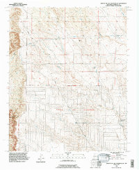
1990 Map of Arroyo De Las Calabacillas
USGS Topo · Published 1996About this map
The Town of Alameda grant lands dominate the lower half of this landscape, where the high desert terrain is carved by complex drainage systems. Most prominent is the Arroyo de las Calabacillas, which winds toward the developing edges of Rio Rancho in the southeast. This 1990 revision, based on imagery dating back to 1952, captures a period of transition as infrastructure begins to mark the open country. A series of pipelines and an aqueduct cut across the northern sections, following the natural contours of the land near Arroyo de los Montoyas. The map clearly delineates the Grant Boundary, a critical feature for understanding historic land tenure in Sandoval County. Modern expansion is signaled by the presence of Northern Blvd, providing a look at how the region's transport network was adapting to the growing residential footprint near Arroyo Pantaleon.
Find a feature on this map
10 named features on this map. Tap any name to fly to it.
Don’t see what you’re looking for? This feature index may not catch every label — zoom into the map to look around manually.
Map Details
Editions of this 1990 Arroyo De Las Calabacillas Map
This is the sole edition of this map. No revisions or reprints were ever made.
Other maps of this area

1888 · Bernalillo
USGS Topo · 1:125,000

1889 · Albuquerque
USGS Topo · 1:125,000

1893 · Albuquerque
USGS Topo · 1:125,000

1934 · Griegos
USGS Topo · 1:24,000

1938 · Albuquerque
USGS Topo · 1:62,500

1953 · Bernalillo NW
USGS Topo · 1:24,000

1954 · Volcano Ranch
USGS Topo · 1:24,000

1954 · Loma Machete
USGS Topo · 1:24,000

1954 · Sky Village
USGS Topo · 1:24,000
1954 · Sky Village SE
USGS Topo · 1:24,000