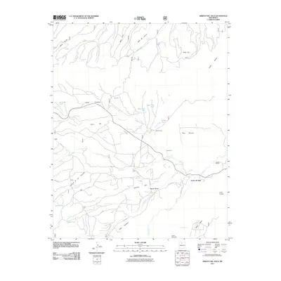
2011 Map of Arroyo Del Agua
USGS Topo · Published 2011About this map
Arroyo del Agua and the surrounding high-desert mesas in Rio Arriba County are defined by a network of drainage systems and small settlements tied to the land. The confluence of the Rio Puerco and Salitral Creek serves as a geographic anchor for local activity, where the small community of Santa Teresa sits near the winding banks. The landscape is heavily marked by traditional land use patterns, evidenced by numerous named springs such as Cordovas Spring and Fuertes Spring, which are essential for livestock in this arid environment.
Find a feature on this map
55 named features on this map. Tap any name to fly to it.
Don’t see what you’re looking for? This feature index may not catch every label — zoom into the map to look around manually.
Map Details
Editions of this 2011 Arroyo Del Agua Map
This is the sole edition of this map. No revisions or reprints were ever made.
Other maps of this area

1909 · Gallina
USGS Topo · 1:125,000

1940 · Cuba
USGS Topo · 1:62,500

1943 · Cuba
USGS Topo · 1:62,500

1953 · Cerro Del Grant
USGS Topo · 1:24,000

1953 · Echo Ampitheater
USGS Topo · 1:24,000

1953 · Arroyo Del Agua
USGS Topo · 1:24,000
1953 · Jarosa
USGS Topo · 1:24,000

1953 · Laguna Peak
USGS Topo · 1:24,000

1953 · Youngsville
USGS Topo · 1:24,000
1953 · Youngsville
USGS Topo · 1:62,500