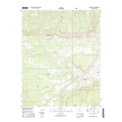
2017 Map of Arroyo Del Agua
USGS Topo · Published 2017About this map
Arroyo del Agua and Coyote anchor this high-desert landscape in Rio Arriba County, where the southern reaches of the Santa Fe National Forest meet complex canyon and mesa systems. The terrain is defined by water management and topography, featuring numerous livestock tanks and natural springs such as Gurule Spring, Sandy Deer Spring, and Lino Spring. These water sources were vital for the high-altitude ranching and settlement patterns visible across Mesa Alta and Mesa Poleo. The Continental Divide National Scenic Trail winds through the center of the sheet, crossing Salitral Cr and passing near Canoncito Seco. The map provides a contemporary record of the rugged forest road network, including Forest Rd 103 and Forest Rd 418, which link remote family-named landmarks like Mesa Gurule and Canoncito de los Cordovas within the traditional Spanish land grant region.
Find a feature on this map
66 named features on this map. Tap any name to fly to it.
Don’t see what you’re looking for? This feature index may not catch every label — zoom into the map to look around manually.
Map Details
Editions of this 2017 Arroyo Del Agua Map
This is the sole edition of this map. No revisions or reprints were ever made.
Other maps of this area

1909 · Gallina
USGS Topo · 1:125,000

1940 · Cuba
USGS Topo · 1:62,500

1943 · Cuba
USGS Topo · 1:62,500

1953 · Cerro Del Grant
USGS Topo · 1:24,000

1953 · Echo Ampitheater
USGS Topo · 1:24,000

1953 · Arroyo Del Agua
USGS Topo · 1:24,000
1953 · Jarosa
USGS Topo · 1:24,000

1953 · Laguna Peak
USGS Topo · 1:24,000

1953 · Youngsville
USGS Topo · 1:24,000
1953 · Youngsville
USGS Topo · 1:62,500