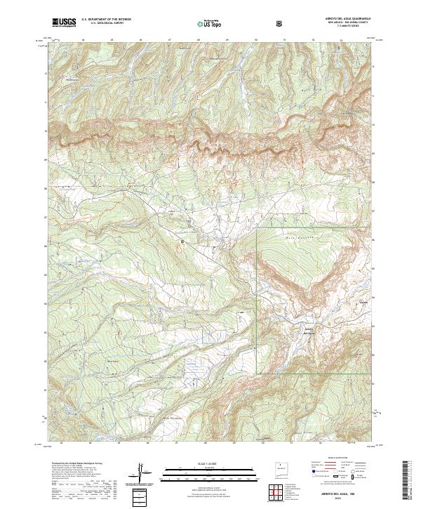
2023 Map of Arroyo Del Agua
USGS Topo · Published 2023About this map
Arroyo del Agua and the nearby settlement of Coyote anchor this high-elevation landscape in Rio Arriba County, where the desert floor meets the rising mesas of northern New Mexico. The geography is defined by a series of prominent plateaus, including Mesa Gurule, Mesa Poleo, and Mesa Montosa, which are dissected by deep canyons and seasonal drainage systems like Salitral Creek and the Rio Puerco. This area within the Santa Fe National Forest and the Chama River Canyon Wilderness shows a long-standing reliance on dispersed water sources, evidenced by numerous named springs such as Gurule Spring, Lino Spring, and Cordovas Spring, alongside man-made improvements like La Cueva Tank. The presence of the Continental Divide National Scenic Trl and various forest routes indicates the area's modern role in recreation and resource management.
Find a feature on this map
60 named features on this map. Tap any name to fly to it.
Don’t see what you’re looking for? This feature index may not catch every label — zoom into the map to look around manually.
Map Details
Editions of this 2023 Arroyo Del Agua Map
This is the sole edition of this map. No revisions or reprints were ever made.
Other maps of this area

1909 · Gallina
USGS Topo · 1:125,000

1940 · Cuba
USGS Topo · 1:62,500

1943 · Cuba
USGS Topo · 1:62,500

1953 · Cerro Del Grant
USGS Topo · 1:24,000

1953 · Echo Ampitheater
USGS Topo · 1:24,000

1953 · Arroyo Del Agua
USGS Topo · 1:24,000
1953 · Jarosa
USGS Topo · 1:24,000

1953 · Laguna Peak
USGS Topo · 1:24,000

1953 · Youngsville
USGS Topo · 1:24,000
1953 · Youngsville
USGS Topo · 1:62,500