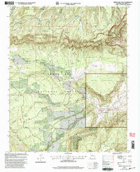
2002 Map of Arroyo Del Agua
USGS Topo · Published 2003About this map
Santa Fe National Forest encompasses much of this high-altitude landscape, where the Rio Puerco carves through the eastern terrain near the settlement of Arroyo del Agua. The map reveals a complex system of water management essential for this arid environment, evidenced by numerous tanks like the Mesa Alta Wildlife Trick Tank and La Cueva Tank. Local administrative and religious life is anchored by the Coyote Ranger Sta and the Santa Teresa Ch, reflecting the dual presence of federal land management and established community centers. The geography is defined by prominent mesas, including Mesa Alta, Mesa Montosa, and Mesa Poleo, which overlook a network of seasonal drainages such as Agua Sarca Creek and Salitral Creek. This survey captures a moment of modern land use where 4WD trails provide access to remote wildlife resources and ranching infrastructure like Ojo Corral within the protected bounds of the Chama River Canyon Wilderness.
Find a feature on this map
57 named features on this map. Tap any name to fly to it.
Don’t see what you’re looking for? This feature index may not catch every label — zoom into the map to look around manually.
Map Details
Editions of this 2002 Arroyo Del Agua Map
This is the sole edition of this map. No revisions or reprints were ever made.
Other maps of this area

1909 · Gallina
USGS Topo · 1:125,000

1940 · Cuba
USGS Topo · 1:62,500

1943 · Cuba
USGS Topo · 1:62,500

1953 · Cerro Del Grant
USGS Topo · 1:24,000

1953 · Echo Ampitheater
USGS Topo · 1:24,000

1953 · Arroyo Del Agua
USGS Topo · 1:24,000
1953 · Jarosa
USGS Topo · 1:24,000

1953 · Laguna Peak
USGS Topo · 1:24,000

1953 · Youngsville
USGS Topo · 1:24,000
1953 · Youngsville
USGS Topo · 1:62,500