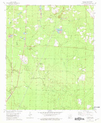
1981 Map of Artesian
USGS Topo · Published 1981About this map
The Artesian Oil Field and Lloyd Creek Oil Field define the economic landscape of this portion of Calhoun County during the early 1980s. This survey, based on 1970s aerial photography, reveals a region where resource extraction and rural community life existed side-by-side. Small settlements like Artesian are anchored by spiritual and social centers such as Happy Home Ch, Trinity Chapel, and Antioch Ch. The terrain is heavily dissected by watercourses, including Little Champagnolle Creek and Hurricane Creek, which wind through a landscape dotted with numerous Gravel Pits. Local genealogy and history are preserved at sites like Friendship Cem and Faustina Ch Cem, while the Artesian Lookout Tower stands as a prominent landmark for forestry and fire management.
Find a feature on this map
27 named features on this map. Tap any name to fly to it.
Don’t see what you’re looking for? This feature index may not catch every label — zoom into the map to look around manually.
Map Details
Editions of this 1981 Artesian Map
This is the sole edition of this map. No revisions or reprints were ever made.
Other maps of this area

1903 · Camden
USGS Topo · 1:125,000

1934 · Moro Bay
USGS Topo · 1:62,500

1938 · Moro Bay
USGS Topo · 1:62,500

1939 · Moro Bay
USGS Topo · 1:62,500

1953 · El Dorado
USGS Topo · 1:250,000

1957 · El Dorado
USGS Topo · 1:250,000

1958 · El Dorado
USGS Topo · 1:250,000

1960 · El Dorado
USGS Topo · 1:250,000

1962 · Smackover NE
USGS Topo · 1:24,000
1962 · Calion
USGS Topo · 1:24,000