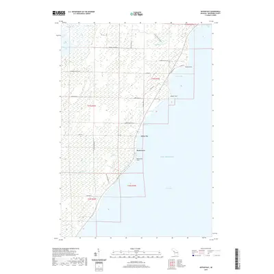
2019 Map of Arthur Bay
USGS Topo · Published 2019About this map
Lake Michigan dominates the eastern horizon of this Menominee County coastal survey, where the rugged shoreline of Green Bay is defined by a series of prominent landforms including Harbor Point, Sawyer Point, and Rochereau Point. The coastal settlements of Beach Grove and Arthur Bay are connected by a network of local roads and logging routes, such as the Cherry Ridge Logging Rd and Jimtown Road F 3, which penetrate the interior wetlands. Inland, the hydrology is characterized by several water bodies and drainages, most notably Hayward Lake, Little Lake, and the winding course of Big Brook. The distribution of residential lanes and secondary roads like Hayward Bay Dr and N Bay de Noc Ln suggests a landscape shaped by both timber interests and seasonal lakeside living during the early twenty-first century.
Find a feature on this map
40 named features on this map. Tap any name to fly to it.
Don’t see what you’re looking for? This feature index may not catch every label — zoom into the map to look around manually.
Map Details
Editions of this 2019 Arthur Bay Map
This is the sole edition of this map. No revisions or reprints were ever made.
Other maps of this area

1939 · Marinette
USGS Topo · 1:48,000

1949 · Stephenson
USGS Topo · 1:48,000

1954 · Escanaba
USGS Topo · 1:250,000

1957 · Escanaba
USGS Topo · 1:250,000

1958 · Escanaba
USGS Topo · 1:250,000

1961 · Chambers Island
USGS Topo · 1:62,500

1963 · Cedar River
USGS Topo · 1:62,500
1963 · Birch Creek
USGS Topo · 1:24,000

1963 · Stephenson
USGS Topo · 1:62,500
1963 · Marinette
USGS Topo · 1:62,500