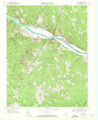
1968 Map of Arvonia
USGS Topo · Published 1971About this map
The James River corridor defines this landscape, where the Chesapeake and Ohio railroad follows the northern bank past historic estates like Bremo Mansion and Lower Bremo Mansion. The 1968 landscape shows a region deeply connected to the river and rail economy, with the John H Cocke Memorial Bridge linking Fluvanna and Buckingham counties. In the southern half of the map, the community of Arvonia is marked by a prominent Quarry, signaling the area's geological and industrial character near Slate Hill. Numerous rural landmarks for genealogists include Seven Islands Chapel, Arvon Ch, and the Bettie Cem. The transition from river bottom to higher ground is dotted with small settlements such as New Canton, Bremo Bluff, and Le Sueur, alongside several small schools like the Chestnut Grove Sch and Carver Sch.
Find a feature on this map
49 named features on this map. Tap any name to fly to it.
Don’t see what you’re looking for? This feature index may not catch every label — zoom into the map to look around manually.
Map Details
Editions of this 1968 Arvonia Map
2 editions found
Other maps of this area

1891 · Palmyra
USGS Topo · 1:125,000

1895 · Palmyra
USGS Topo · 1:125,000

1897 · Palmyra
USGS Topo · 1:125,000

1943 · Scottsville
USGS Topo · 1:62,500

1946 · Scottsville
USGS Topo · 1:62,500

1947 · Roanoke
USGS Topo · 1:250,000

1950 · Dillwyn
USGS Topo · 1:62,500

1958 · Dillwyn
USGS Topo · 1:62,500

1959 · Roanoke
USGS Topo · 1:250,000

1960 · Columbia
USGS Topo · 1:62,500