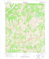
1972 Map of Ashbrook
USGS Topo · Published 1973About this map
Baxter Ridge and Pleasant Hill define the dissected uplands of this Kentucky landscape, situated where Anderson, Washington, and Mercer counties meet. By the early 1970s, the modern corridor of the Blue Grass Parkway (also labeled as the Toll Road) cut through the southern half of the quadrangle, contrasting with the winding networks of Salt River and Chaplin River that drain the territory.
Find a feature on this map
54 named features on this map. Tap any name to fly to it.
Don’t see what you’re looking for? This feature index may not catch every label — zoom into the map to look around manually.
Map Details
Editions of this 1972 Ashbrook Map
3 editions found
Other maps of this area

1905 · Harrodsburg
USGS Topo · 1:125,000

1922 · Frankfort
USGS Topo · 1:48,000

1923 · Waddy
USGS Topo · 1:48,000

1924 · Frankfort
USGS Topo · 1:62,500

1925 · Mount Eden
USGS Topo · 1:48,000

1927 · Mount Eden
USGS Topo · 1:62,500

1951 · Lawrenceburg
USGS Topo · 1:24,000

1952 · Cornishville
USGS Topo · 1:24,000

1952 · Ashbrook
USGS Topo · 1:24,000

1952 · Chaplin
USGS Topo · 1:24,000