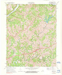
1972 Map of Ashbrook
USGS Topo · Published 1976About this map
Ashbrook and the surrounding rural uplands of Anderson County are defined by a network of ridges and winding watercourses as they appeared in the early 1970s. The landscape is carved by the Salt River and the Chaplin River, with numerous small communities such as Sinai and Johnsonville scattered among the high ground of Baxter Ridge and Pleasant Hill Ridge. This era shows a community in transition, with the modern Blue Grass Parkway cutting through a countryside still deeply rooted in older patterns of settlement. Dozens of small family and community cemeteries are located near landmarks like New Liberty Ch and Mt Pleasant Ch, providing a detailed look at the local geography before suburban shifts significantly altered these traditional Kentucky crossroads.
Find a feature on this map
43 named features on this map. Tap any name to fly to it.
Don’t see what you’re looking for? This feature index may not catch every label — zoom into the map to look around manually.
Map Details
Editions of this 1972 Ashbrook Map
3 editions found
Other maps of this area

1905 · Harrodsburg
USGS Topo · 1:125,000

1922 · Frankfort
USGS Topo · 1:48,000

1923 · Waddy
USGS Topo · 1:48,000

1924 · Frankfort
USGS Topo · 1:62,500

1925 · Mount Eden
USGS Topo · 1:48,000

1927 · Mount Eden
USGS Topo · 1:62,500

1951 · Lawrenceburg
USGS Topo · 1:24,000

1952 · Cornishville
USGS Topo · 1:24,000

1952 · Ashbrook
USGS Topo · 1:24,000

1952 · Chaplin
USGS Topo · 1:24,000