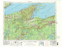
1953 Map of Ashland
USGS Topo · Published 1983About this map
The Apostle Islands archipelago stands as the dominant geographic feature along the northern coast of Wisconsin in this mid-century portrait of the Lake Superior region. Surveyed by the U.S. Geological Survey with revisions through the early 1960s, the map details a landscape where indigenous lands like the Red Cliff Indian Reservation and Bad River Indian Reservation meet the expansive timberlands of the Chequamegon National Forest. The industrial heart of the region is centered on the port cities of Ashland and Bayfield, and the iron mining hubs of Ironwood and Hurley at the Michigan border.
Find a feature on this map
219 named features on this map. Tap any name to fly to it.
Don’t see what you’re looking for? This feature index may not catch every label — zoom into the map to look around manually.
Map Details
Editions of this 1953 Ashland Map
3 editions found

Other maps of this area

1895 · Duluth
USGS Topo · 1:62,500

1915 · Superior
USGS Topo · 1:48,000

1917 · Superior
USGS Topo · 1:62,500

1938 · Lac Du Flambeau
USGS Topo · 1:48,000

1939 · Lac Du Flambeau
USGS Topo · 1:48,000

1939 · Winchester
USGS Topo · 1:48,000

1940 · Mercer
USGS Topo · 1:48,000

1940 · Butternut
USGS Topo · 1:48,000

1940 · Upson
USGS Topo · 1:48,000

1941 · Bayfield
USGS Topo · 1:48,000