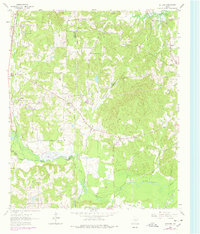
1962 Map of Ashland
USGS Topo · Published 1978About this map
Lake O' the Pines dominates the northern reaches of this East Texas terrain, where the waters of Arms Creek and Eagle Creek gather along the shoreline of the Pines. This area is a patchwork of rural crossroad communities and timbered bottoms, reflecting the transition of the mid-20th century landscape. Near Ashland, the presence of a Landing Strip and numerous Borrow Pits indicates localized industrial activity and infrastructure development. The map meticulously records the intersection of three counties, where Upshur, Gregg, and Harrison boundaries meet. Genealogists can trace early family sites through landmarks like Jones Cem, Shady Grove Cem, and Davis Cem, while local churches such as Davidson Chapel and Shady Grove Ch serve as enduring anchors for the surrounding settlements of Old Diana and Macedonia.
Find a feature on this map
32 named features on this map. Tap any name to fly to it.
Don’t see what you’re looking for? This feature index may not catch every label — zoom into the map to look around manually.
Map Details
Editions of this 1962 Ashland Map
2 editions found
Other maps of this area

1956 · Tyler
USGS Topo · 1:250,000

1960 · White Oak
USGS Topo · 1:24,000

1960 · Coffeeville
USGS Topo · 1:24,000

1960 · Glenwood
USGS Topo · 1:24,000

1961 · Hallsville
USGS Topo · 1:24,000

1961 · Lassater
USGS Topo · 1:24,000

1961 · Harleton
USGS Topo · 1:24,000

1962 · Ashland
USGS Topo · 1:24,000

1962 · Longview Heights
USGS Topo · 1:24,000

1962 · Ore City
USGS Topo · 1:24,000