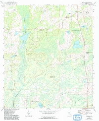
1962 Map of Ashville
USGS Topo · Published 1993About this map
The Aucilla River and Little Aucilla River define the wetlands of the Florida Panhandle on the border of Jefferson and Madison counties. This landscape is characterized by its numerous named water bodies, ranging from the open water of Sneads Smokehouse Lake to the secluded Old Fern Pond and Blue Pond. The small settlement of Ashville serves as a local hub, anchored by the Ashville Lookout Tower and a series of rural spiritual centers.
Find a feature on this map
29 named features on this map. Tap any name to fly to it.
Don’t see what you’re looking for? This feature index may not catch every label — zoom into the map to look around manually.
Map Details
Editions of this 1962 Ashville Map
2 editions found
Other maps of this area

1954 · Greenville
USGS Topo · 1:24,000

1954 · Greenville NE
USGS Topo · 1:24,000

1954 · Valdosta
USGS Topo · 1:250,000

1955 · Lamont
USGS Topo · 1:24,000

1956 · Grooverville
USGS Topo · 1:24,000

1956 · Monticello NE
USGS Topo · 1:24,000

1956 · Baden
USGS Topo · 1:24,000

1958 · Valdosta
USGS Topo · 1:250,000

1959 · Valdosta
USGS Topo · 1:250,000

1962 · Ashville
USGS Topo · 1:24,000