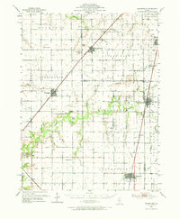
1952 Map of Assumption
USGS Topo · Published 1973About this map
Blue Mound and Stonington anchor this mid-century survey of the Central Illinois prairie, where the drainage of Mosquito Creek and Flat Branch define the agricultural landscape. The region’s economic life follows the tracks of the Wabash RR and the Illinois Central RR, with grain elevators and rail sidings serving the small towns along the Christian and Macon county line. A deep local history is evident in the cluster of rural institutions, such as Old Stonington Ch and the Brushy Branch Sch, alongside numerous family-named burial grounds like Bilyeu Cem and Traughber Cem. The presence of the Mc Coy Airport near Stonington and several oil wells scattered through the southern townships indicates a postwar shift toward diversified infrastructure, even as traditional township boundaries like Prairie Ton and May remain firmly established.
Find a feature on this map
82 named features on this map. Tap any name to fly to it.
Don’t see what you’re looking for? This feature index may not catch every label — zoom into the map to look around manually.
Map Details
Editions of this 1952 Assumption Map
2 editions found

Other maps of this area

1923 · Taylorville
USGS Topo · 1:62,500

1925 · Taylorville
USGS Topo · 1:62,500

1929 · Decatur
USGS Topo · 1:62,500

1933 · Decatur
USGS Topo · 1:62,500

1942 · Shelbyville
USGS Topo · 1:62,500

1946 · Shelbyville
USGS Topo · 1:62,500

1946 · Nokomis
USGS Topo · 1:62,500

1947 · Pana
USGS Topo · 1:62,500

1949 · Dalton City
USGS Topo · 1:62,500

1949 · Nokomis
USGS Topo · 1:62,500