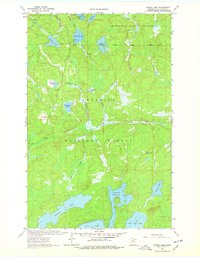
1963 Map of Astrid Lake
USGS Topo · Published 1978About this map
The Jeanette State Forest and Superior National Forest converge in this northern Minnesota wilderness, where a complex network of glacial lakes and creeks defines the landscape of St. Louis County. In the early 1960s, the terrain remained largely wild, dominated by large bodies of water such as Oriniack Lake and Trout Lake. The map reveals evidence of resource management and early outdoor recreation, including scattered Gravel Pits and a designated Campsite along Maude Lake. A prominent human landmark is the Norway Lookout Tower, positioned to monitor the dense timberlands. The hydrological pattern is particularly intricate, with named waterways like Gustafson Creek and Norway Creek connecting smaller basins like Foldsgold Lake and Gustafson Lake across the forest floor.
Find a feature on this map
29 named features on this map. Tap any name to fly to it.
Don’t see what you’re looking for? This feature index may not catch every label — zoom into the map to look around manually.
Map Details
Editions of this 1963 Astrid Lake Map
3 editions found

Other maps of this area

1954 · Hibbing
USGS Topo · 1:250,000

1954 · International Falls
USGS Topo · 1:250,000

1956 · Sioux Pine Island
USGS Topo · 1:24,000

1956 · Vermilion Dam
USGS Topo · 1:24,000

1956 · Chad Lake
USGS Topo · 1:24,000

1957 · Hibbing
USGS Topo · 1:250,000

1957 · International Falls
USGS Topo · 1:250,000

1958 · International Falls
USGS Topo · 1:250,000

1958 · Hibbing
USGS Topo · 1:250,000

1963 · Echo Lake
USGS Topo · 1:24,000