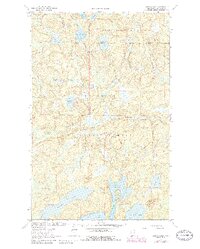
1963 Map of Astrid Lake
USGS Topo · Published 1986About this map
Lake Jeanette State Forest and the Superior National Forest define this landscape in northern St. Louis County, where water and timber dictate the geography. The map shows a complex network of glacial lakes and interconnecting streams, including Astrid Lake, Maude Lake, and Lake Crellin. Human activity is primarily oriented toward recreation and natural resource management, evidenced by several designated campsites, a Picnic Area, and the Norway Lookout Tower perched on a high ridge. To the south, the terrain transitions into the Boundary Waters Canoe Area Wilderness, specifically surrounding the North Arm of Trout Lake and Oriniack Lake. Small-scale industrial activity appears at the northern edge near the Gravel Pits, while names like Foolsgold Lake and Saltpark Lake suggest the colorful local vernacular of earlier prospectors and woodsmen.
Find a feature on this map
28 named features on this map. Tap any name to fly to it.
Don’t see what you’re looking for? This feature index may not catch every label — zoom into the map to look around manually.
Map Details
Editions of this 1963 Astrid Lake Map
3 editions found

Other maps of this area

1954 · Hibbing
USGS Topo · 1:250,000

1954 · International Falls
USGS Topo · 1:250,000

1956 · Sioux Pine Island
USGS Topo · 1:24,000

1956 · Vermilion Dam
USGS Topo · 1:24,000

1956 · Chad Lake
USGS Topo · 1:24,000

1957 · Hibbing
USGS Topo · 1:250,000

1957 · International Falls
USGS Topo · 1:250,000

1958 · International Falls
USGS Topo · 1:250,000

1958 · Hibbing
USGS Topo · 1:250,000

1963 · Echo Lake
USGS Topo · 1:24,000