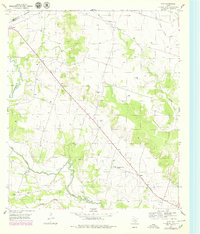
1955 Map of Ater
USGS Topo · Published 1979About this map
Leon River and its meandering tributaries dominate this mid-century view of the Central Texas landscape, where small agricultural communities and rural landmarks anchor the terrain. The settlement of Ater sits near the river's path, while the 36th Division Memorial Highway cuts a straight line southeast through the area, passing Ames and the Ames Community Center. The map documents a transition in transportation, showing the Old Railroad Grade north of Plum Creek, indicating a rail line already out of service by the time of the 1955 survey.
Find a feature on this map
18 named features on this map. Tap any name to fly to it.
Don’t see what you’re looking for? This feature index may not catch every label — zoom into the map to look around manually.
Map Details
Editions of this 1955 Ater Map
2 editions found
Other maps of this area

1888 · Meridian
USGS Topo · 1:125,000

1894 · Meridian
USGS Topo · 1:125,000

1894 · Gatesville
USGS Topo · 1:125,000

1947 · Purmela
USGS Topo · 1:62,500

1947 · Gatesville West
USGS Topo · 1:24,000

1947 · Purmela
USGS Topo · 1:24,000

1947 · Gatesville East
USGS Topo · 1:24,000
1950 · Gatesville
USGS Topo · 1:62,500

1954 · Waco
USGS Topo · 1:250,000
1954 · Gatesville West
USGS Topo · 1:24,000