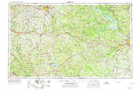
1953 Map of Athens
USGS Topo · Published 1974About this map
The Athens and Augusta corridor in the mid-1960s serves as a primary axis of Georgia’s Piedmont region, characterized by a complex network of river systems and evolving transportation routes. The Savannah River defines the eastern boundary, while the Oconee River and its various forks feed into Lake Sinclair in the south. This era shows the landscape transitioning from traditional agriculture toward managed timberlands and federal land use, evidenced by the presence of the Oconee National Forest and the Piedmont National Wildlife Refuge.
Find a feature on this map
186 named features on this map. Tap any name to fly to it.
Don’t see what you’re looking for? This feature index may not catch every label — zoom into the map to look around manually.
Map Details
Editions of this 1953 Athens Map
3 editions found

Other maps of this area

1888 · Atlanta
USGS Topo · 1:125,000

1890 · Suwanee
USGS Topo · 1:125,000

1890 · Atlanta
USGS Topo · 1:125,000

1891 · Gainesville
USGS Topo · 1:125,000

1891 · Carnesville
USGS Topo · 1:125,000

1892 · Mc Cormick
USGS Topo · 1:125,000

1892 · Abbeville
USGS Topo · 1:125,000

1892 · Atlanta
USGS Topo · 1:125,000

1893 · Elberton
USGS Topo · 1:125,000

1894 · Suwanee
USGS Topo · 1:125,000