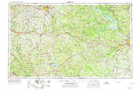
1980 Map of Athens
USGS Topo · Published 1981This historical map portrays the area of Athens in 1980, primarily covering Clarke County as well as portions of Gwinnett County, Taliaferro County, Oglethorpe County, Jasper County, Oconee County, Madison County, Newton County, Walton County, Rockdale County, Barrow County, Jackson County, Morgan County, and Greene County. Featuring a scale of 1:100000, this map provides a highly detailed snapshot of the terrain, roads, buildings, counties, and historical landmarks in the Athens region at the time. Published in 1981, it is one of 2 known editions of this map due to revisions or reprints.
Find a feature on this map
128 named features on this map. Tap any name to fly to it.
Don’t see what you’re looking for? This feature index may not catch every label — zoom into the map to look around manually.
Map Details
Editions of this 1980 Athens Map
2 editions found
Historical Maps of Alcovy Mountain Through Time
6 maps found