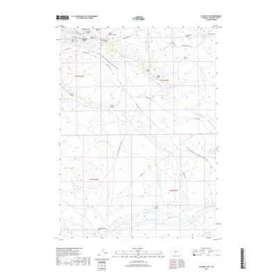
2017 Map of Atlantic City
USGS Topo · Published 2017About this map
Atlantic City serves as the focal point for this high-country survey in Fremont County, where historical transit routes converge in the Wyoming wilderness. The landscape is defined by the winding course of the Sweetwater River and an intricate network of irrigation systems such as the Beaver Dam Ditch and Burnt Ranch Ditch. This area is a significant corridor for both historical and modern travel, featuring the preserved path of the Oregon Trl alongside the Continental Divide National Scenic Trail. Traces of the region's mining and frontier past are evident in the vivid local nomenclature, from Beer Garden Gulch and Slaughterhouse Gulch near the settlement to the Point of Rocks South Pass Stag Rd that cuts across the southern flats. The terrain is deeply etched by watercourses like Rock Cr and Willow Cr, creating a complex series of gulches and ridges that dictated the movement of early pioneers and later homesteaders.
Find a feature on this map
78 named features on this map. Tap any name to fly to it.
Don’t see what you’re looking for? This feature index may not catch every label — zoom into the map to look around manually.
Map Details
Editions of this 2017 Atlantic City Map
This is the sole edition of this map. No revisions or reprints were ever made.
Other maps of this area

1953 · Gravel Spring
USGS Topo · 1:24,000

1953 · Radium Springs
USGS Topo · 1:24,000

1953 · Atlantic City
USGS Topo · 1:24,000

1953 · Louis Lake
USGS Topo · 1:24,000

1953 · South Pass City
USGS Topo · 1:24,000

1954 · Miners Delight
USGS Topo · 1:24,000

1955 · Lander
USGS Topo · 1:250,000

1958 · Lander
USGS Topo · 1:250,000

1958 · Circle Bar Lake
USGS Topo · 1:24,000

1958 · Dickie Springs
USGS Topo · 1:24,000