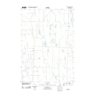
2011 Map of Atwood
USGS Topo · Published 2011About this map
The settlement of Atwood sits near the eastern shores of Grand Traverse Bay, anchoring a landscape defined by an intricate network of small glacial lakes and connecting creeks. This 2011 survey illustrates the rural character of Banks Township, where agricultural parcels are interspersed with specialized features like the Antrim Dells Golf Course. The area is notably rich in genealogical sites, with several distinct burial grounds including the Antrim Cemetery, Atwood Cemetery, Catholic Cemetery, and Ellsworth Cemetery distributed throughout the countryside. A complex drainage system moves water through basins such as Little Torch Lake, Mud Lake, and Lake Marion, while numerous smaller bodies like Moblo Lake and Matchett Lake dot the interior. The northeastern corner reaches toward the community of Phelps, marking a transition toward the larger inland lake systems characteristic of this Michigan peninsula.
Find a feature on this map
102 named features on this map. Tap any name to fly to it.
Don’t see what you’re looking for? This feature index may not catch every label — zoom into the map to look around manually.
Map Details
Editions of this 2011 Atwood Map
This is the sole edition of this map. No revisions or reprints were ever made.
Other maps of this area

1954 · Central Lake
USGS Topo · 1:62,500

1954 · Charlevoix
USGS Topo · 1:62,500

1955 · Cheboygan
USGS Topo · 1:250,000

1958 · Cheboygan
USGS Topo · 1:250,000

1958 · Bayshore
USGS Topo · 1:62,500

1961 · Boyne City
USGS Topo · 1:62,500

1975 · Boyne City NW
USGS Topo · 1:24,000
1983 · Ellsworth
USGS Topo · 1:25,000
1983 · Atwood
USGS Topo · 1:24,000
1983 · Central Lake
USGS Topo · 1:25,000