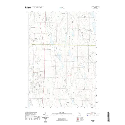
2019 Map of Atwood
USGS Topo · Published 2019About this map
The boundary between Charlevoix and Antrim counties divides this northern Michigan landscape, where a series of small, glacially-carved lakes define the local geography. The settlement of Ellsworth serves as a focal point in the eastern portion, situated near Eaton Lake and Ellsworth Cemetery. Further west, the small community of Atwood is positioned along a north-south corridor, supported by the nearby Atwood Cemetery and Catholic Cemetery. The terrain is marked by a complex network of creeks such as Skinner Creek and Burnard Creek that feed into scattered water bodies including Little Torch Lake, Mud Lake, and Toad Lake. This 2019 survey documents a rural landscape where section-line roads like Barnard Road and Church Road overlay a topography of drumlins and wetlands, illustrating the persistent agricultural and residential patterns of the Barnard and Phelps vicinities.
Find a feature on this map
107 named features on this map. Tap any name to fly to it.
Don’t see what you’re looking for? This feature index may not catch every label — zoom into the map to look around manually.
Map Details
Editions of this 2019 Atwood Map
This is the sole edition of this map. No revisions or reprints were ever made.
Other maps of this area

1954 · Central Lake
USGS Topo · 1:62,500

1954 · Charlevoix
USGS Topo · 1:62,500

1955 · Cheboygan
USGS Topo · 1:250,000

1958 · Cheboygan
USGS Topo · 1:250,000

1958 · Bayshore
USGS Topo · 1:62,500

1961 · Boyne City
USGS Topo · 1:62,500

1975 · Boyne City NW
USGS Topo · 1:24,000
1983 · Ellsworth
USGS Topo · 1:25,000
1983 · Atwood
USGS Topo · 1:24,000
1983 · Central Lake
USGS Topo · 1:25,000