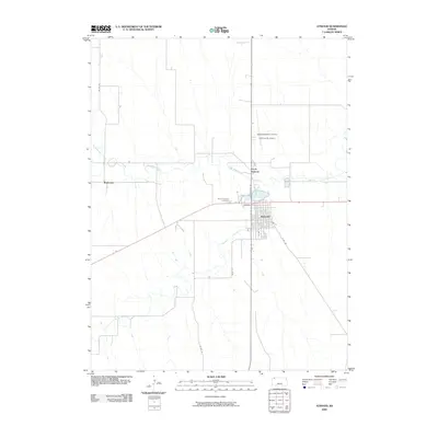
2009 Map of Atwood
USGS Topo · Published 2009About this map
Atwood serves as the central hub of this Rawlins County landscape, where the confluence of several watercourses defines the local geography. The town is situated near the junction where Little Beaver Creek and Beaver Creek meet, while North Beaver Creek cuts through the northwest corner of the quadrangle. The grid of the settlement is well-established, featuring primary corridors such as Sherman St and Blaine St, and the residential layout extends toward North Atwood.
Find a feature on this map
16 named features on this map. Tap any name to fly to it.
Don’t see what you’re looking for? This feature index may not catch every label — zoom into the map to look around manually.
Map Details
Editions of this 2009 Atwood Map
This is the sole edition of this map. No revisions or reprints were ever made.
Other maps of this area

1951 · Herndon
USGS Topo · 1:62,500

1951 · Achilles
USGS Topo · 1:62,500

1951 · Atwood
USGS Topo · 1:62,500

1951 · Chardon
USGS Topo · 1:62,500

1954 · Goodland
USGS Topo · 1:250,000

1956 · Goodland
USGS Topo · 1:250,000

1957 · Goodland
USGS Topo · 1:250,000
1978 · Beardsley
USGS Topo · 1:24,000
1978 · Atwood
USGS Topo · 1:24,000
1978 · Ludell
USGS Topo · 1:24,000