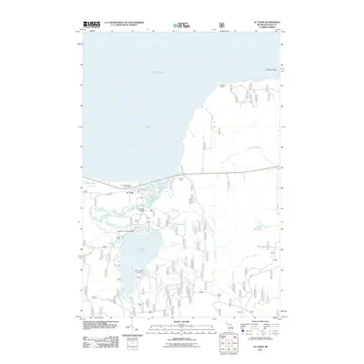
2011 Map of Au Train
USGS Topo · Published 2011About this map
Au Train sits at the mouth of the Au Train River where it meets the southern shore of Lake Superior. This coastal landscape is defined by the transition from the sandy expanse of Au Train Bay to the inland waters of Au Train Lake. The settlement pattern follows the river's winding path, connected by landmarks like the Doucette Bridge and the Cameron Crossing Bridge. Moving inland, the terrain shifts from the shoreline to a network of creeks and small falls, including Scott Falls and Cole Creek Falls. Local history is anchored by the Au Train Township Cemetery, while the recreational character of the area is highlighted by the Au Train Lake Campground. To the east, the landscape becomes more secluded, featuring the Cedar Bog Lake and the prominent Ridge that overlooks the forest and wetlands of Alger County.
Find a feature on this map
39 named features on this map. Tap any name to fly to it.
Don’t see what you’re looking for? This feature index may not catch every label — zoom into the map to look around manually.
Map Details
Editions of this 2011 Au Train Map
This is the sole edition of this map. No revisions or reprints were ever made.
Other maps of this area

1958 · Munising
USGS Topo · 1:62,500

1958 · Au Train
USGS Topo · 1:62,500

1958 · Wood Island
USGS Topo · 1:62,500

1958 · Marquette
USGS Topo · 1:250,000

1960 · Marquette
USGS Topo · 1:250,000

1961 · Marquette
USGS Topo · 1:250,000

1968 · Marquette
USGS Topo · 1:250,000

1983 · Munising
USGS Topo · 1:100,000
1984 · Au Sable Point
USGS Topo · 1:100,000
1985 · Munising
USGS Topo · 1:24,000