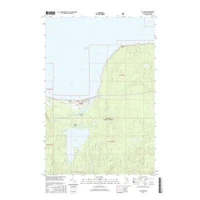
2017 Map of Au Train
USGS Topo · Published 2017About this map
Lake Superior shorelines define the northern edge of this coastal landscape, where the Au Train River flows into the protected waters of Au Train Bay. The settlement of Au Train sits at this river mouth, serving as a gateway to the extensive wooded tracts of the Hiawatha National Forest. Inland, the geography is characterized by numerous water bodies and wetlands, including the large Au Train Lake with its southern Buck Bay, as well as smaller features like Paulson Lake and Cedar Bog Lake. The presence of the Au Train Township Cem and various river crossings, such as Douchette Bridge and Cameron Crossing Bridge, provide specific points of interest for genealogists and local historians tracing the development of this Alger County community. For outdoor researchers, the route of the N Country National Scenic Trail winds through the forest, passing natural landmarks like Cole Creek Falls.
Find a feature on this map
26 named features on this map. Tap any name to fly to it.
Don’t see what you’re looking for? This feature index may not catch every label — zoom into the map to look around manually.
Map Details
Editions of this 2017 Au Train Map
This is the sole edition of this map. No revisions or reprints were ever made.
Other maps of this area

1958 · Munising
USGS Topo · 1:62,500

1958 · Au Train
USGS Topo · 1:62,500

1958 · Wood Island
USGS Topo · 1:62,500

1958 · Marquette
USGS Topo · 1:250,000

1960 · Marquette
USGS Topo · 1:250,000

1961 · Marquette
USGS Topo · 1:250,000

1968 · Marquette
USGS Topo · 1:250,000

1983 · Munising
USGS Topo · 1:100,000
1984 · Au Sable Point
USGS Topo · 1:100,000
1985 · Munising
USGS Topo · 1:24,000