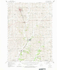
1957 Map of Audubon
USGS Topo · Published 1981About this map
The East Nishnabotna River carves a central path through this mid-century agricultural landscape, defining the layout of the valley's transit and towns. The Chicago and North Western railroad parallels the river south from Audubon, connecting the settlements of Hamlin, Exira, and Brayton. This 1950s survey documents a dense network of rural one-room schools, many already marked as School No 8 (Abandoned) or School No 5 (Abandoned), signaling the consolidation of the rural education system.
Find a feature on this map
62 named features on this map. Tap any name to fly to it.
Don’t see what you’re looking for? This feature index may not catch every label — zoom into the map to look around manually.
Map Details
Editions of this 1957 Audubon Map
2 editions found
Other maps of this area

1954 · Omaha
USGS Topo · 1:250,000

1957 · Omaha
USGS Topo · 1:250,000

1957 · Audubon
USGS Topo · 1:62,500

1958 · Omaha
USGS Topo · 1:250,000

1971 · Coon Rapids South
USGS Topo · 1:24,000

1971 · Viola Center
USGS Topo · 1:24,000

1971 · Adair South
USGS Topo · 1:24,000

1971 · Anita
USGS Topo · 1:24,000

1971 · Wiota
USGS Topo · 1:24,000

1971 · Atlantic
USGS Topo · 1:24,000