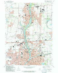
1993 Map of Aurora North
USGS Topo · Published 1994About this map
The Fox River corridor serves as the industrial and civic spine of this region during the early 1990s, connecting the bustling centers of Aurora, Batavia, and Geneva. This map captures a landscape defined by institutional growth and the preservation of open space, notably the massive ring of the Fermi National Accelerater Laboratory on the eastern edge. Along the river, a string of conservation areas like the Fabyan County Forest Preserve and Les Arends Co For Presv alternate with dense residential blocks and historic cemeteries.
Find a feature on this map
84 named features on this map. Tap any name to fly to it.
Don’t see what you’re looking for? This feature index may not catch every label — zoom into the map to look around manually.
Map Details
Editions of this 1993 Aurora North Map
This is the sole edition of this map. No revisions or reprints were ever made.
Other maps of this area

1892 · Joliet
USGS Topo · 1:62,500

1908 · Wheaton
USGS Topo · 1:62,500

1923 · Joliet
USGS Topo · 1:62,500

1925 · Yorkville
USGS Topo · 1:62,500

1932 · Geneva
USGS Topo · 1:62,500

1948 · Wheaton
USGS Topo · 1:62,500

1948 · Geneva
USGS Topo · 1:62,500

1949 · Geneva
USGS Topo · 1:24,000

1950 · Aurora North
USGS Topo · 1:24,000

1953 · Naperville
USGS Topo · 1:24,000