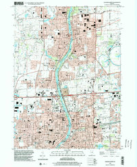
1998 Map of Aurora North
USGS Topo · Published 2002About this map
The Fox River valley corridor, as it appeared in the late 1990s, reveals a densely integrated landscape of academic institutions, scientific research facilities, and residential expansion. Dominating the eastern portion of the sheet is the Fermi National Accelerator Laboratory, its circular footprint a stark contrast to the surrounding suburban street grids. This era shows the continued growth of Aurora and Batavia, where educational landmarks such as Aurora University and the Illinois Mathematical & Science Acad sit alongside established community centers like Mooseheart.
Find a feature on this map
81 named features on this map. Tap any name to fly to it.
Don’t see what you’re looking for? This feature index may not catch every label — zoom into the map to look around manually.
Map Details
Editions of this 1998 Aurora North Map
This is the sole edition of this map. No revisions or reprints were ever made.
Other maps of this area

1892 · Joliet
USGS Topo · 1:62,500

1908 · Wheaton
USGS Topo · 1:62,500

1923 · Joliet
USGS Topo · 1:62,500

1925 · Yorkville
USGS Topo · 1:62,500

1932 · Geneva
USGS Topo · 1:62,500

1948 · Wheaton
USGS Topo · 1:62,500

1948 · Geneva
USGS Topo · 1:62,500

1949 · Geneva
USGS Topo · 1:24,000

1950 · Aurora North
USGS Topo · 1:24,000

1953 · Naperville
USGS Topo · 1:24,000