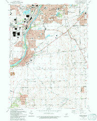
1993 Map of Aurora South
USGS Topo · Published 1994About this map
The Fox River carves through this portion of Kendall and Kane Counties, serving as the central axis for the growing communities of Oswego and Montgomery. By the early 1990s, suburban expansion is evident in the residential density of Boulder Hill and Scraper-Moecherville, yet the southern reaches of the map retain a grid of rural roads such as Wooley Road and Collins Road. Local heritage is anchored by several historic burial grounds, including Oswego Prairie Cem, St Pauls Cem, and French Cem.
Find a feature on this map
65 named features on this map. Tap any name to fly to it.
Don’t see what you’re looking for? This feature index may not catch every label — zoom into the map to look around manually.
Map Details
Editions of this 1993 Aurora South Map
This is the sole edition of this map. No revisions or reprints were ever made.
Other maps of this area

1892 · Joliet
USGS Topo · 1:62,500

1908 · Wheaton
USGS Topo · 1:62,500

1923 · Joliet
USGS Topo · 1:62,500

1925 · Yorkville
USGS Topo · 1:62,500

1932 · Geneva
USGS Topo · 1:62,500

1948 · Wheaton
USGS Topo · 1:62,500

1948 · Geneva
USGS Topo · 1:62,500

1950 · Aurora North
USGS Topo · 1:24,000

1953 · Plattville
USGS Topo · 1:24,000

1953 · Naperville
USGS Topo · 1:24,000