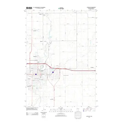
2013 Map of Austin East
USGS Topo · Published 2013About this map
The Cedar River corridor dominates this view of Mower County, shaping the development of Austin and its surrounding communities. The river’s path is marked by significant water control and recreation sites, including Ramsey Mill Pond and E Side Lake. The urban landscape is characterized by a dense grid of streets punctuated by local landmarks like the Mower County Fairgrounds and the Historic Roosevelt Bridge. Transportation infrastructure is a central theme, with the Austin Municipal Airport occupying a large tract to the east and major routes like the I-90 corridor bisecting the city.
Find a feature on this map
59 named features on this map. Tap any name to fly to it.
Don’t see what you’re looking for? This feature index may not catch every label — zoom into the map to look around manually.
Map Details
Editions of this 2013 Austin East Map
This is the sole edition of this map. No revisions or reprints were ever made.
Other maps of this area

1954 · Hayward
USGS Topo · 1:62,500

1954 · Austin
USGS Topo · 1:62,500

1954 · Mason City
USGS Topo · 1:250,000

1957 · Mason City
USGS Topo · 1:250,000

1958 · Mason City
USGS Topo · 1:250,000

1966 · Waltham
USGS Topo · 1:24,000

1966 · Sargeant
USGS Topo · 1:24,000

1967 · Blooming Prairie
USGS Topo · 1:24,000
1982 · Austin East
USGS Topo · 1:24,000
1982 · London
USGS Topo · 1:24,000