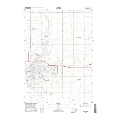
2016 Map of Austin East
USGS Topo · Published 2016About this map
The Cedar River and its tributaries carve a complex path through this landscape, influencing the development of Austin and its satellite communities. The river’s presence is central to the area's history, marked by the Historic Roosevelt Bridge and the impounded waters of the Ramsey Mill Pond and Mill Pond. These water bodies, along with East Side Lake and Turtle Cr, reveal how the natural hydrology was adapted for both industrial use and municipal recreation. Settlement patterns are clearly defined by the clustered developments of Mapleview, Ramsey, and Andyville to the north, while Austin Acres and Nicolville anchor the eastern and southern reaches.
Find a feature on this map
100 named features on this map. Tap any name to fly to it.
Don’t see what you’re looking for? This feature index may not catch every label — zoom into the map to look around manually.
Map Details
Editions of this 2016 Austin East Map
This is the sole edition of this map. No revisions or reprints were ever made.
Other maps of this area

1954 · Hayward
USGS Topo · 1:62,500

1954 · Austin
USGS Topo · 1:62,500

1954 · Mason City
USGS Topo · 1:250,000

1957 · Mason City
USGS Topo · 1:250,000

1958 · Mason City
USGS Topo · 1:250,000

1966 · Waltham
USGS Topo · 1:24,000

1966 · Sargeant
USGS Topo · 1:24,000

1967 · Blooming Prairie
USGS Topo · 1:24,000
1982 · Austin East
USGS Topo · 1:24,000
1982 · London
USGS Topo · 1:24,000