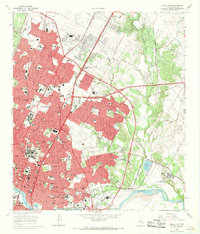
1966 Map of Austin East
USGS Topo · Published 1969About this map
The Colorado River and the emerging Town Lake anchor this mid-1960s view of the Texas capital, a period when the city's academic and civic core was expanding rapidly. The massive footprint of the University of Texas and the State Capitol grounds dominate the central landscape, surrounded by foundational institutions like the Austin State Hospital and Huston-Tillotson College. The map captures a pre-jetport era for the city's air travel, showing the detailed layout of the Robert Mueller Municipal Airport before its eventual redevelopment. Historical depth is visible in the numerous cemeteries such as Oakwood Cemetery and Fiskville Cem, alongside the French Embassy and Elisabet Ney Museum. Transportation patterns are defined by the Southern Pacific and Missouri Kansas Texas railroads, which weave through established neighborhoods and past industrial landmarks like the Town Lake Dam.
Find a feature on this map
146 named features on this map. Tap any name to fly to it.
Don’t see what you’re looking for? This feature index may not catch every label — zoom into the map to look around manually.
Map Details
Editions of this 1966 Austin East Map
Other maps of this area

1896 · Austin
USGS Topo · 1:125,000

1897 · Austin
USGS Topo · 1:125,000

1910 · Austin
USGS Topo · 1:125,000

1932 · Mt. Bonnell
USGS Topo · 1:62,500

1954 · Austin East
USGS Topo · 1:24,000

1954 · Austin West
USGS Topo · 1:24,000

1954 · Austin
USGS Topo · 1:250,000

1955 · Montopolis
USGS Topo · 1:24,000

1955 · Oak Hill
USGS Topo · 1:24,000

1955 · Montopolis
USGS Topo · 1:62,500