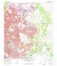
1966 Map of Austin East
USGS Topo · Published 1975About this map
The State Capitol and the University of Texas anchor this mid-century portrait of a rapidly expanding Texas capital. The urban core, characterized by dense blocks and landmark institutions like Brackenridge Hospital and the French Legation, gives way to the evolving eastern and northern suburbs. Post-war growth is evident in the development around Robert Mueller Municipal Airport and the sprawling medical and administrative campuses, including the Austin State Hospital and Texas Dept of Public Safety.
Find a feature on this map
123 named features on this map. Tap any name to fly to it.
Don’t see what you’re looking for? This feature index may not catch every label — zoom into the map to look around manually.
Map Details
Editions of this 1966 Austin East Map
Other maps of this area

1896 · Austin
USGS Topo · 1:125,000

1897 · Austin
USGS Topo · 1:125,000

1910 · Austin
USGS Topo · 1:125,000

1932 · Mt. Bonnell
USGS Topo · 1:62,500

1954 · Austin East
USGS Topo · 1:24,000

1954 · Austin West
USGS Topo · 1:24,000

1954 · Austin
USGS Topo · 1:250,000

1955 · Montopolis
USGS Topo · 1:24,000

1955 · Oak Hill
USGS Topo · 1:24,000

1955 · Montopolis
USGS Topo · 1:62,500