
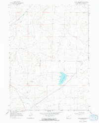
1964 Map of Austin Reservoir
USGS Topo · Published 1968About this map
The Union Pacific railroad corridor anchors the northern reach of this high-desert landscape in Uinta County, passing through the small settlement of Elkhurst. The surrounding terrain is defined by the winding course of Muddy Creek and the stark geological markers of The Pinnacle and The Nipple. Water management in this arid region is central to the landscape, dominated by the Austin Reservoir and the extensive Austin Canal system that cuts across the township lines. A series of pipelines and local infrastructure near Austin show the mid-century development of the area's resource network. The map captures the balance between the industrial demands of the rail line and the agricultural necessity of water distribution in the Wyoming basin during the early 1960s.
Find a feature on this map
14 named features on this map. Tap any name to fly to it.
Don’t see what you’re looking for? This feature index may not catch every label — zoom into the map to look around manually.
Map Details
Editions of this 1964 Austin Reservoir Map
2 editions found
Other maps of this area

1954 · Ogden
USGS Topo · 1:250,000

1958 · Ogden
USGS Topo · 1:250,000

1960 · Ogden
USGS Topo · 1:250,000

1964 · Fort Bridger
USGS Topo · 1:24,000

1964 · Carter
USGS Topo · 1:24,000

1964 · Mountain View
USGS Topo · 1:24,000
1965 · Millersville
USGS Topo · 1:24,000
1965 · Turtle Hill
USGS Topo · 1:24,000

1969 · Hampton
USGS Topo · 1:24,000
1969 · Church Butte
USGS Topo · 1:24,000