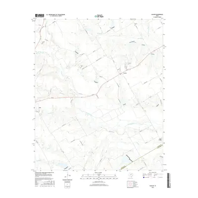
2016 Map of Avalon
USGS Topo · Published 2016About this map
Avalon and the surrounding farmland of southern Ellis County are defined by a dense network of creek branches and rural cemeteries that anchor the local genealogy. The landscape is carved by Chambers Creek and its many tributaries, including White Rock Br, Big Onion Cr, and Hog Cr. Several historic burial grounds, such as Hughes Cem, Maloney Cem, and Dean Cem, are situated along rural routes like Hughes Cemetary Rd and Feaster Rd. This 2016 survey captures the area before modern sprawling development, showing the community of Italy at the western edge and the small settlement of Lone Cedar to the southeast. The map reveals how local transit remains tied to historic paths like Old Hwy 34 and the junction at Main St in Avalon.
Find a feature on this map
64 named features on this map. Tap any name to fly to it.
Don’t see what you’re looking for? This feature index may not catch every label — zoom into the map to look around manually.
Map Details
Editions of this 2016 Avalon Map
This is the sole edition of this map. No revisions or reprints were ever made.
Other maps of this area

1954 · Dallas
USGS Topo · 1:250,000

1956 · Ennis
USGS Topo · 1:62,500

1958 · Dallas
USGS Topo · 1:250,000

1960 · Boz
USGS Topo · 1:24,000

1961 · Forreston
USGS Topo · 1:24,000

1962 · Ennis West
USGS Topo · 1:24,000

1962 · Cryer Creek
USGS Topo · 1:24,000
1965 · Avalon
USGS Topo · 1:24,000
1965 · Blooming Grove
USGS Topo · 1:24,000
1965 · Italy
USGS Topo · 1:24,000