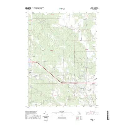
2023 Map of Averill
USGS Topo · Published 2023About this map
The Tittabawassee River winds through the heart of this landscape, anchoring the settlements of Sanford and Averill. The area is defined by an extensive drainage network, including Sturgeon Creek, Dittmar Drain, and Bensch Drain, reflecting the hydrologic complexity of Midland County. Near the southern boundary, the campus of Northwood University sits adjacent to the Midland Municipal Cem, while the Jack Barstow Airport occupies the southeastern corner.
Find a feature on this map
72 named features on this map. Tap any name to fly to it.
Don’t see what you’re looking for? This feature index may not catch every label — zoom into the map to look around manually.
Map Details
Editions of this 2023 Averill Map
This is the sole edition of this map. No revisions or reprints were ever made.
Other maps of this area

1934 · Sanford
USGS Topo · 1:62,500

1936 · Sanford
USGS Topo · 1:62,500

1954 · Midland
USGS Topo · 1:250,000

1958 · Midland
USGS Topo · 1:250,000

1959 · Midland
USGS Topo · 1:250,000

1962 · Midland South
USGS Topo · 1:24,000

1962 · Midland North
USGS Topo · 1:24,000

1966 · Midland
USGS Topo · 1:250,000
1969 · Hope
USGS Topo · 1:24,000
1969 · Edenville
USGS Topo · 1:24,000