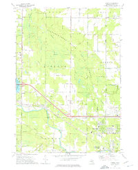
1973 Map of Averill
USGS Topo · Published 1976About this map
Tittabawassee River and its various tributaries, including Sturgeon Creek and Averill Creek, define the landscape of this region northwest of Midland. The map illustrates a period of educational and infrastructure development, featuring the Northwood Institute campus and a cluster of schools such as Woodcrest Sch, Perkins Sch, and St Paul Sch. Transportation networks are prominent, with the Chesapeake and Ohio railroad cutting diagonally across the terrain, passing through the settlement of Averill.
Find a feature on this map
57 named features on this map. Tap any name to fly to it.
Don’t see what you’re looking for? This feature index may not catch every label — zoom into the map to look around manually.
Map Details
Editions of this 1973 Averill Map
This is the sole edition of this map. No revisions or reprints were ever made.
Other maps of this area

1934 · Sanford
USGS Topo · 1:62,500

1936 · Sanford
USGS Topo · 1:62,500

1954 · Midland
USGS Topo · 1:250,000

1958 · Midland
USGS Topo · 1:250,000

1959 · Midland
USGS Topo · 1:250,000

1962 · Midland South
USGS Topo · 1:24,000

1962 · Midland North
USGS Topo · 1:24,000

1966 · Midland
USGS Topo · 1:250,000
1969 · Hope
USGS Topo · 1:24,000
1969 · Edenville
USGS Topo · 1:24,000