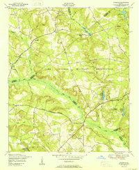
1950 Map of Avondale
USGS Topo · Published 1950About this map
Camp Gordon Military Reservation occupies a significant portion of this landscape, established across the borders of Richmond, Jefferson, and McDuffie counties. The map, based on aerial photography from 1947, documents a rural Georgia environment where military activity and traditional agricultural life exist in close proximity. Outside the reservation boundaries, the community of Avondale is surrounded by family-named landmarks and institutions that suggest a long-established local genealogy, such as Reeves School and Silver Run Church.
Find a feature on this map
41 named features on this map. Tap any name to fly to it.
Don’t see what you’re looking for? This feature index may not catch every label — zoom into the map to look around manually.
Map Details
Editions of this 1950 Avondale Map
This is the sole edition of this map. No revisions or reprints were ever made.
Other maps of this area

1919 · Gough
USGS Topo · 1:62,500

1920 · Stapleton
USGS Topo · 1:62,500

1922 · Harlem
USGS Topo · 1:62,500

1922 · Hephzibah
USGS Topo · 1:62,500

1948 · Hephzibah
USGS Topo · 1:62,500

1948 · Harlem
USGS Topo · 1:62,500

1948 · Stapleton
USGS Topo · 1:62,500

1948 · Gough
USGS Topo · 1:62,500

1948 · Blythe
USGS Topo · 1:24,000

1948 · Harlem
USGS Topo · 1:24,000