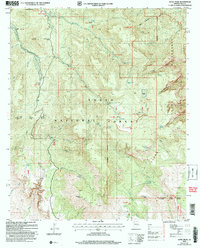
2004 Map of Aztec Peak
USGS Topo · Published 2007About this map
Sierra Ancha and its high-elevation landmarks dominate this 2004 revision, showcasing a landscape defined by dramatic elevation changes and essential water sources. The map highlights the intersection of the Salome Wilderness and the Sierra Ancha Wilderness, centered on the 7,694-foot summit of Aztec Peak with its prominent Lookout Tower. This area served as a vital resource hub for early ranching and mining operations, evidenced by the inclusion of Armer Ranch and Murphy Ranch.
Find a feature on this map
80 named features on this map. Tap any name to fly to it.
Don’t see what you’re looking for? This feature index may not catch every label — zoom into the map to look around manually.
Map Details
Editions of this 2004 Aztec Peak Map
This is the sole edition of this map. No revisions or reprints were ever made.
Other maps of this area

1907 · Roosevelt
USGS Topo · 1:125,000

1909 · Four Peaks
USGS Topo · 1:125,000

1912 · Roosevelt
USGS Topo · 1:125,000

1922 · Chrysotile
USGS Topo · 1:125,000

1949 · McFadden Peak
USGS Topo · 1:62,500

1949 · Rockinstraw Mtn
USGS Topo · 1:62,500

1950 · Rockinstraw Mtn
USGS Topo · 1:62,500

1950 · McFadden Peak
USGS Topo · 1:62,500

1954 · Mesa
USGS Topo · 1:250,000

1957 · Mesa
USGS Topo · 1:250,000