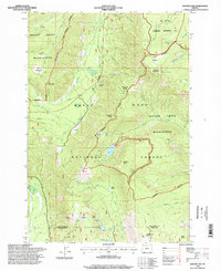
1996 Map of Badger Lake
USGS Topo · Published 1998About this map
Badger Lake and the high ridges of the Mount Hood National Forest dominate this mid-1990s survey, capturing the rugged intersection of the Mount Hood Wilderness and the Badger Creek Wilderness. The landscape is a network of alpine basins and steep drainage divides, where the East Fork Hood River and Dog River originate. The map documents recreation and resource management infrastructure during the late 20th century, ranging from the The Dalles Watershed Management Unit to primitive sites like Camp Windy and the Valley View Cabin.
Find a feature on this map
65 named features on this map. Tap any name to fly to it.
Don’t see what you’re looking for? This feature index may not catch every label — zoom into the map to look around manually.
Map Details
Editions of this 1996 Badger Lake Map
This is the sole edition of this map. No revisions or reprints were ever made.
Other maps of this area

1924 · Mount Hood
USGS Topo · 1:125,000

1927 · Mount Hood
USGS Topo · 1:125,000

1930 · Dufur
USGS Topo · 1:125,000

1934 · Dufur
USGS Topo · 1:125,000

1953 · The Dalles
USGS Topo · 1:250,000

1956 · The Dalles
USGS Topo · 1:250,000

1956 · Mt. Wilson
USGS Topo · 1:62,500

1957 · The Dalles
USGS Topo · 1:250,000

1962 · Rock Creek Reservoir
USGS Topo · 1:24,000

1962 · Cathedral Ridge
USGS Topo · 1:24,000