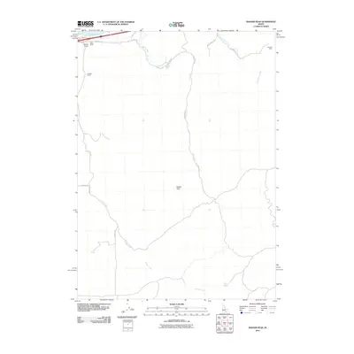
2010 Map of Badger Peak
USGS Topo · Published 2010About this map
Badger Peak dominates the central landscape of this Cassia County survey, overlooking a network of high-desert drainages and isolated agricultural outposts. The northern edge of the map is defined by the shoreline of Lake Walcott, where Cold Water Camp sits near the head of Lanes Gulch. This 2010 snapshot illustrates a rural economy centered on ranching and water access, evidenced by the Barkdull Ranch and Campbell Ranch connected by a series of primitive roads including Fall Creek Rd and Benson Spring Rd. In the south, the terrain descends toward Calder Creek, where Dairy Spring provides a critical water source in a landscape otherwise defined by intermittent flows like Little Warm Creek. The map provides a clear look at the township and range survey lines that govern the placement of local thoroughfares such as 150 North Rd and 3300 East Rd.
Find a feature on this map
20 named features on this map. Tap any name to fly to it.
Don’t see what you’re looking for? This feature index may not catch every label — zoom into the map to look around manually.
Map Details
Editions of this 2010 Badger Peak Map
This is the sole edition of this map. No revisions or reprints were ever made.
Other maps of this area

1934 · Rockland
USGS Topo · 1:62,500

1937 · Rockland
USGS Topo · 1:62,500

1954 · Pocatello
USGS Topo · 1:250,000

1958 · Pocatello
USGS Topo · 1:250,000

1958 · Sublett
USGS Topo · 1:62,500

1959 · Yale
USGS Topo · 1:62,500
1971 · Neeley
USGS Topo · 1:24,000

1971 · Rockland West
USGS Topo · 1:24,000

1973 · Hartley Peak
USGS Topo · 1:24,000
1984 · Gifford Spring
USGS Topo · 1:24,000