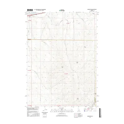
2017 Map of Badger Peak
USGS Topo · Published 2017About this map
Badger Peak anchors this high-elevation portion of the Sublett Range along the border of Power and Cassia Counties. In the north, the waters of Lake Walcott reach into the quadrangle near Lanes Gulch, while the southern reaches are defined by a network of drainage canyons including Dairy Canyon and Houtz Canyon. The terrain is marked by essential water sources for high-country activity, such as Dairy Spring and Calder Spring.
Find a feature on this map
30 named features on this map. Tap any name to fly to it.
Don’t see what you’re looking for? This feature index may not catch every label — zoom into the map to look around manually.
Map Details
Editions of this 2017 Badger Peak Map
This is the sole edition of this map. No revisions or reprints were ever made.
Other maps of this area

1934 · Rockland
USGS Topo · 1:62,500

1937 · Rockland
USGS Topo · 1:62,500

1954 · Pocatello
USGS Topo · 1:250,000

1958 · Pocatello
USGS Topo · 1:250,000

1958 · Sublett
USGS Topo · 1:62,500

1959 · Yale
USGS Topo · 1:62,500
1971 · Neeley
USGS Topo · 1:24,000

1971 · Rockland West
USGS Topo · 1:24,000

1973 · Hartley Peak
USGS Topo · 1:24,000
1984 · Gifford Spring
USGS Topo · 1:24,000