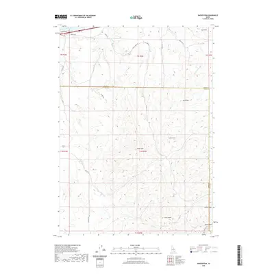
2020 Map of Badger Peak
USGS Topo · Published 2020About this map
Badger Peak serves as the high point of this high-desert landscape within the Sublett Range along the border of Cassia and Power counties. The northern edge of the sheet reaches the waters of Lake Walcott, where Lanes Gulch meets the shoreline. The terrain is defined by a series of north-south canyons and hollows, including the prominent Dairy Canyon and Houtz Canyon, which are fed by vital water sources like Dairy Spring and Calder Spring. This 2020 survey illustrates a sparsely populated region primarily accessed by forest and ranch roads such as Osborn Loop and Nat For Dev Rd 577. The drainage pattern is led by Fall Cr and Little Warm Cr, which carve through the high elevations to the north, while Calder Cr winds through the southern foothills, reflecting the vital role of seasonal waterways in this portion of Idaho.
Find a feature on this map
30 named features on this map. Tap any name to fly to it.
Don’t see what you’re looking for? This feature index may not catch every label — zoom into the map to look around manually.
Map Details
Editions of this 2020 Badger Peak Map
This is the sole edition of this map. No revisions or reprints were ever made.
Other maps of this area

1934 · Rockland
USGS Topo · 1:62,500

1937 · Rockland
USGS Topo · 1:62,500

1954 · Pocatello
USGS Topo · 1:250,000

1958 · Pocatello
USGS Topo · 1:250,000

1958 · Sublett
USGS Topo · 1:62,500

1959 · Yale
USGS Topo · 1:62,500
1971 · Neeley
USGS Topo · 1:24,000

1971 · Rockland West
USGS Topo · 1:24,000

1973 · Hartley Peak
USGS Topo · 1:24,000
1984 · Gifford Spring
USGS Topo · 1:24,000