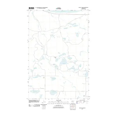
2010 Map of Bagley Lake
USGS Topo · Published 2010About this map
Sandy River and Big Rock Creek define this lake-rich portion of Beltrami County, where the southern reaches of Lower Red Lake meet a landscape dense with smaller water bodies. The terrain is structured by a grid of reservation and county roads, including Res Hwy 8 and County Hwy 72, which navigate between prominent features like Bagley Lake and Balm Lake. Cultural markers are scattered across the landscape, providing essential points for genealogical and local history research. Landmarks such as Big Meadows Lookout Tower and Camp Hiawatha stand near Parks Lake, while the Clover Cemetery and Trinity Cemetery offer specific locations for family history. The distribution of named lakes—including Pine Island Lake, Crooked Lake, and Long Lake—illustrates the intricate hydrography of this Minnesota region during the early 21st century.
Find a feature on this map
50 named features on this map. Tap any name to fly to it.
Don’t see what you’re looking for? This feature index may not catch every label — zoom into the map to look around manually.
Map Details
Editions of this 2010 Bagley Lake Map
This is the sole edition of this map. No revisions or reprints were ever made.
Other maps of this area

1919 · Solway
USGS Topo · 1:62,500

1919 · Churnes
USGS Topo · 1:62,500

1943 · Solway
USGS Topo · 1:62,500

1943 · Bagley
USGS Topo · 1:62,500

1954 · Bemidji
USGS Topo · 1:250,000

1957 · Bemidji
USGS Topo · 1:250,000

1958 · Bemidji
USGS Topo · 1:250,000

1969 · Leonard
USGS Topo · 1:24,000

1972 · Bagley Lake
USGS Topo · 1:24,000
1972 · Debs
USGS Topo · 1:24,000