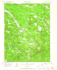
1945 Map of Bailey
USGS Topo · Published 1964About this map
The North Fork South Platte River carves through this mountain corridor, serving as the primary axis for travel and settlement at the close of World War II. The community of Bailey serves as a central hub, supported by a network of ranching operations including Potter Ranch, Lydia Ranch, and Shaffer Ranch. This landscape reflects a period of established mountain habitation where civic infrastructure like the Pine Gulch Sch and Dry Creek Sch provided for local families, while the Bailey Ranger Sta managed the surrounding forests. The map captures a transition in land use, showing traditional holdings like Fitzsimmons Ranch alongside the residential developments of Wandcrest Park and Will-O-The-Wisp. Further east along the river, the small settlements of Insmont and Estabrook mark the path of the mountain canyon.
Find a feature on this map
43 named features on this map. Tap any name to fly to it.
Don’t see what you’re looking for? This feature index may not catch every label — zoom into the map to look around manually.
Map Details
Editions of this 1945 Bailey Map
5 editions found
Other maps of this area

1893 · Platte Canyon
USGS Topo · 1:125,000

1899 · West Denver
USGS Topo · 1:125,000

1903 · Georgetown
USGS Topo · 1:62,500

1905 · Georgetown
USGS Topo · 1:62,500

1945 · Pine
USGS Topo · 1:24,000

1945 · Bailey
USGS Topo · 1:24,000

1945 · Shawnee
USGS Topo · 1:24,000

1948 · Pine
USGS Topo · 1:24,000

1948 · Shawnee
USGS Topo · 1:24,000

1949 · Bailey
USGS Topo · 1:24,000