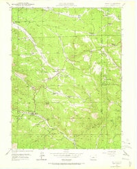
1945 Map of Bailey
USGS Topo · Published 1973About this map
Pike National Forest encompasses much of this 1940s landscape, where the North Fork South Platte River winds through a terrain defined by isolated ranching outposts and high-altitude settlements. The map documents a cluster of homesteads and operations including the Potter Ranch, Fitzsimmons Ranch, and Shaffer Ranch, illustrating the dispersed residential patterns typical of the Colorado front range before mid-century modernization.
Find a feature on this map
49 named features on this map. Tap any name to fly to it.
Don’t see what you’re looking for? This feature index may not catch every label — zoom into the map to look around manually.
Map Details
Editions of this 1945 Bailey Map
5 editions found
Other maps of this area

1893 · Platte Canyon
USGS Topo · 1:125,000

1899 · West Denver
USGS Topo · 1:125,000

1903 · Georgetown
USGS Topo · 1:62,500

1905 · Georgetown
USGS Topo · 1:62,500

1945 · Pine
USGS Topo · 1:24,000

1945 · Bailey
USGS Topo · 1:24,000

1945 · Shawnee
USGS Topo · 1:24,000

1948 · Pine
USGS Topo · 1:24,000

1948 · Shawnee
USGS Topo · 1:24,000

1949 · Bailey
USGS Topo · 1:24,000